Categories
Tourism Malaysia

Exploring Taman Negara

Taman Negara is the crown jewel of tropical rainforests in Asia. Reputed as the oldest of its kind in the world (130 million years old), it has evolved amid natural disasters and been generally unmolested by human civilisation — creating an epicentre for the most diverse distribution of flora and fauna on the planet. There’s 150 mammal species ranging from tiny rodents to magnificent Indian elephants, 479 species of birds and a host of native animals unique to Malaysia.


Established in 1939 under British rule, Taman Negara is a whopping 4343 square kilometres spanning three states. The expanse is covered in a criss-cross of meandering rivers, rapids and waterfalls; a mountain range and lush valleys with 30 to 40 metre canopies that obscure the sunlight.

Banyan buttressed roots in Taman Negara

Banyan buttressed roots in Taman Negara


As the forest reserve is so big — it would literally take years or even decades to fully explore with scientists discovering new species all the time — we have condensed the itinerary to focus on the

must-see sights and must-do activities for first time visitors.

 Jungle Trekking

You can’t go to Taman Negara and not trek into the depths of the jungle. During the day you can see rare jungle flowers and take amazing photos at the base of 40m tall trees with gargantuan banyan buttressed roots. Also keep your eyes peeled for sightings of the gorgeous pitcher plant species. There are various trails to choose from, all for different levels of ability. For the more adventurous, check out the 53km long distance trail from Kuala Tahan to Gunung Tahan. It takes seven days and six nights and is one of the most challenging trails and seldom explored in the park.

Night Jungle Walk

The fun begins when the sun sets. Most fauna here are generally crepuscular (active between dusk and dawn) or nocturnal so the best time to catch a glimpse of native wild animals is after dark. Some trails run along rivers that are known to be feeding grounds for seladang (Malaysian gaurs), deers, monkeys and wild boars. If you are really lucky, you may spot a well-camouflaged black panther stalking in the trees or a herd of elephants dipping their trunks into the stream. If you fail to spot any wildlife, head to the salt licks and the animal observatories at Tahan Hide or Kumbang Hide, where there is ample deers, wild boars and Malayan tapir to see.

The Canopy Walkway at Taman Negara is a must!

The Canopy Walkway at Taman Negara is a must!

Canopy Walkway

Taman Negara’s canopy walkway is arguably one of the longest in the world at 530m and is 40m above the ground. The dense canopy is home to a myriad of bird species and arboreal animals that have formed complex ecosystems at such altitude. It is also common to see certain trees towering above the walkway and these giants are estimated to by thousands of years old. Interestingly, the walkway was initially built for research purposes, but is now the most common attraction at the park and can be reached by boat or trekking, just 1.2km from Park HQ.


Orang Asli Villages

Although Taman Negara is relatively pristine and untouched, the tribal people have coexisted here for thousands of years. The Batek and Semokberi aborigines have beautiful rustic settlements where they use blowpipes and spears to hunt game. They are very approachable and friendly people but are extremely superstitious as well so visitors are advised to respect their traditions and cultures. If you want to take a photo of them, make sure you ask for permission first.

Batek people have been living in Taman Negara for centuries — nationalgeographic.com

Batek people have been living in Taman Negara for centuries — nationalgeographic.com

Adventure Exploration

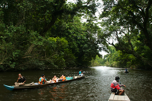
If you are an adrenaline junkie, jump on a wooden boat that will rip through the seven river rapids of Sungai Tembeling. The rapids are highly rated and you will definitely be drenched by the end of the journey. Alternatively, you can cruise upstream to Late Berkoh, one of the most photographed areas of Taman Negara. There’s also finishing adventures for the serious angler, with popular spots including Kuala Perkai, Rincing, Rawa and Lata Said. The best fishing months are during drier months in February to September of the year.

A journey to Late Berkoh will be one to remember — www.tamannegara.asia

A journey to Late Berkoh will be one to remember — www.tamannegara.asia

Gunung Tahan

Gunung Tahan is the tallest peak in Peninsula Malaysia at 2,187m and takes four days to reach the top with camping needed each night. Depending on your fitness levels, you can traverse the old trail which usually take six to seven days of trekking through valleys.hilly areas and rivers and is 32km longer. You will need to register and pay a small fee for access and be sure to have water proof flash lights with back up batteries as well as a custom built first aid kit. To learn more about Gunung Tahan hiking, click here: http://www.tamannegara.asia/packages/other-packages/gunung-tahan-expedition/

For more information about your ultimate Taman Negara experience go to: http://www.tamannegara.asia/

Categories
Tourism Malaysia

Climb of Hope

February 25, 2012 at 6:58 am

We at Malaysia.com would like to help publicise a worthwhile cause brought to us by Gary Heng of the NGO called Shelter Home for Children.

They provide shelter, education, clothing and love to neglected, abandoned and abused children and are in their 31st year of operations.

Their “Climb of Hope” campaign aims to get 30 climbers to help raise RM 2,000 each to help fund the operations of their shelter home.

For more information, please check out http://www.shelterhome.org/ and more details are provided below:

A very good day to you from all of us at Shelter Home for Children. We are
please to know that you have a keen passion and determination to conquer
Mount Kinabalu (Malaysia) and at the same time raise RM2,000 in the
process. We rest assure you that it will be a most memorable highlights of
your life after making this climb.

Our target is to raise RM 100,000 which will be used to improve the
standard of education of the abused children in Shelter.


2011 Mount KK Climb (iS) - 025

2011 Mount KK Climb (iS) - 090

2011 Mount KK Climb (iS) - 093

2011 Mount KK Climb (iS) - 129

Logo_Shelter_1

We are pleased to propose the below:-

4 Days 3 Nights Mount Kinabalu Climbing and Kundasang

Group Name : Shelter Climb For Charity 2012

Date : 25 till 28 April 2012

Number of Passengers : 28 Paxs + 2 Tour Leaders

Flight Details : To Be Advised

*Day 1 : AIRPORT/PROMENADE HOTEL/LUNCH/PROMENADE HOTEL*

/DINNER/PROMENADE HOTEL

Arrive at Kota Kinabalu Airport and transfer to Promenade Hotel.

1300hrs, proceed for Lunch at local restaurant.

After Lunch, return to hotel.

1800hrs, proceed for Dinner at local restaurant.

After dinner, return to hotel.

Meals : Lunch / Dinner

*Day 2 : PROMENADE HOTEL/KINABALU PARK*

Early Morning, transfer to Kinabalu Park for climb.

Upon arrival to park, meet your guide at Park HQ after your breakfast.
Thereafter you will be

transferred to Timpohon Gate (1,829m) where you will begin your climbing.
Packed Lunch

provided. Dinner at Laban Rata Restaurant. Overnight at the Laban Rata
Resthouse

(dormitory).

Meals Included: Breakfast / Packed Lunch / Dinner

*Day 3: KINABALU PARK/KINABALU PINE RESORT*

0230 Hrs Continue you conquest to the summit of Mt Kinabalu (4,095.2m).
Low’s Peak

(4095.2m) is your summit destination for a spectacular view of the distant
horizon and as far

as eye can see (weather permitted). Breakfast at Laban Rata Resthouse and
descend to

Timpohon Gate.

1300 Hrs Pick-up from Timpohon Gate and transfer to Park Registration
Office, where you can

get a certificate for RM10 each if you have successfully conquered Mt
Kinabalu. Lunch at Park

Restaurant. (1300hrs – 1600hrs shuttle van *every 30 minutes* to Kinabalu
Pine Resort for

check-in) Overnight at Kinabalu Pine Resort in Kundasang.

Meals Included: Breakfast / Lunch / Barbeque Dinner

*Day 4 : KINABALU PINE RESORT/DESA FARM/NABALU MARKET/AIRPORT*

After breafkast, depart for Desa Farm.

1300hrs , proceed to town for own lunch and en route stop to visit the
Nabalu Native Market,

shop before drop-off.

at airport for flight back to KL.

Meal Included: Breakfast

**End of Itinerary**

Rates

*MALAYSIAN CLIMBERS*

No of Pax Package Price Based on Per

Person Basis

Tour Leader

*30 Paying* *Adult RM 2010.00 * Per Person 2 x Tour Leaders

*INTERNATIONAL CLIMBERS*

No of Pax Package Price Based on Per

Person Basis

Tour Leader

*30 Paying Adult RM 2,300.00* Per Person N/A

.

*TOUR FARE INCLUDES*:

* Air and land transport from Shelter One and back inclusive of airport tax.

* 1 night stay at Promenade Hotel Kota Kinabalu based on Deluxe Room (Twin
Sharing)

* 1 night stay at Laban Rata Resthouse based on Dormitory Style

* 1 night stay at Kinabalu Pine Resort based on Standard Room (Twin Sharing)

* Return Airport Transfer / Land Transfer

* English Speaking Guide

* Meals as stated above

* Entrance Fee at Kinabalu Park, Climbing Insurance Climb Permit.

* *Total of 8 Mountain Guides for 30 Climbers. (4 persons per Guide)*

*TOUR FARE EXCLUDE:*

* Alcoholic/ Carbonated Drinks / Juices

* Climbing Certificate at RM10.00 upon completion only

* Video/ Camera Entrance Fee

* Item Not Mention above

* Porters to be arranged and paid directly.

Note:

Sabah Park requires a photocopy of your passport / identity card for
registration

Please be on time. Otherwise you will need to make your own alternative
transportation back

to Kota Kinabalu.

*Recommended items to bring:*

Rain gear, Wind breakers, Warm Clothing, Hat, Gloves, Extra thick socks,
Torchlight, Whistle

and Drinking Water.

PLEASE READ THOROUGHLY

Do not Climb if you have history of Suffering from the following ailments:-

Heart disease,Hypertension. Chronis Asthma, Peptic Ulcer, Severe Anaemia,
Diabetes,

Epileptic Fits, Athritis. Palpitation, Hepatitis (Jaundice), Muscular
Cramps, Obesity (Over

Weight) or ANY other sickness that may be triggered by severe cold,
exertion and high
altitude.

If you have anymore questions regarding this campaign, please call :

Edwin Jalleh : +60 0122574305
Brian Cheong : +60 0123510575

Categories
Tourism Malaysia

To The Top of Mulu Summit (Part 2)

KK1

Words by Ariel Chew, photos by Zainal Abidin Othman


Enter if you dare!


The next morning dawned bright and we woke up feeling chirpy after a good night’s rest.  But to my horror, I discovered my pillow stained with blood.  

The view was pretty – fallen leaves and lovely trees as far as the eye can see.  And when we pause to look further between the trees, we can see the tops of neighbouring mountains – bluish green from a distance. 


Calm surroundings

To Give Up or Not – That Was the Question!

Apparently, I wasn’t the only one who entertained the thought of giving up.  Our boss upon seeing our tired faces as we rested at Camp 2 asked us if we would like to turn back to Camp 1.  One by one, we shook our heads.  If we proceed to Camp 3 at this late hour, it would mean trekking in the dark when the night fell.  The clouds were ominously dark and it might rain at any time.

And so, we slowly got up to our feet, every sore muscle protesting, hoisted our backpacks and went on to one of the hardest journeys we’ve ever known. The rain came strong and heavy.  We hurriedly donned our ponchos, mainly to protect our backpacks even though they were already protected by their rain covers. Although the rain made the slopes slippery, it had a cooling and rejuvenating effect on our tired bodies and strangely enough, made the journey easier. 

There was another group who stayed overnight at Camp 3 after descending from the summit.  They left early in the morning, descending to Camp 1 and then back to Park HQ.  To my relief, they looked none the worse for wear after conquering the summit.  After my harrowing and slow performance getting to Camp 3, I was having serious doubts whether I could actually make it to the summit.  

If you stop to listen, you can hear the slow dripping of water from the rock formations as part of the process of forming a new stalagmite.  Of course, this process is painstakingly long with only about one centimetre growing every hundred years.  Looking at the rock formations in the cave, we guessed that the cave must have been around the block for a long, long while.  The pebbles and rocks on the cave floor resembled those typically found on river beds.  This was evidence that the cave systems were formed by strong gushing underground rivers once upon a time. 

I decided to cross the bridge when I get to it.  At any rate, by reaching Camp 3, I managed to do what 20 soldiers purportedly couldn’t.  With that uplifting thought, I cheerfully packed up, don my wet trekking clothes and together with the others, left for Camp 4 after breakfast.

Camp 3 was cold at night, making it difficult for me to sleep much despite my warm sleeping bag and jacket (perhaps I should have gotten better gloves for my hands were freezing).   

Similar to Camp 1, both camps have basic flush toilets and fire places to cook food but unlike Camp 1, their only source of water was the rainfall collected in several big tanks.  We were thankful for the heavy rainfall on our journey;  for the water tanks were filled to the brim, giving us enough water for cooking and cleaning ourselves.  We used the water to fill our water containers but after applying one water purification tablet into every one litre, of course.   

Day 5 ~ Hie Ho, Hie Ho, It’s off to the Summit We Go!

Waking up before dawn (3.30am to be exact) and getting ourselves out in the freezing cold to climb a steep summit was hardly my idea of fun.  But that was exactly what we did the next morning.  The only consolation was we got to leave our backpacks behind at Camp 4 and just bring necessities to the summit. 

As we climbed guided by our torch lights, we got warmer. As Zainal said earlier, there were two false peaks to go through before we could reach the true peak.  Which meant a series of steep ascends and descends that took the wind out of my sail.Still, that did not deter me from pausing to admire the soft golden glow of sunlight illuminating the lovely trees and stunted vegetation along the way.  The air was crisp and utterly fresh.  There were times when I found myself trudging all alone and I embraced those moments of quietness in the midst of such beauty. 

On the flipside, never had I felt so helpless and terrified either.  At one point, I found myself dangling on both hands with my feet trying in vain to find a firm foothold to pull myself up the 90 degree ledge.  I felt the strength in my arms giving out and I tried to grip the tree roots tighter.  If I were to let go, it would be one steep and long drop.   

It felt like we’ll never reach the elusive summit.  The false twin peaks fed us a lot of false hopes that we have arrived.  But we eventually got there.  Up there, the vegetation resembled adorable bonsai plants and the wind was strong and chilly.  There was also an abandoned battery recharging station/shack, a tall pole that beckoned us to climb it and three poles tied together with a metal pail on top to signal the summit.  


Strange, but intriguing


Night crawler


Black wonder 

Sticking grasshooper 


Back to Camp 3

All that goes up must come down.  And it’s the same for mountain climbers. Our success not only lies in conquering the summit but to return safely to our point of origin.  

The descent from the summit to Camp 4 took as long as the ascent earlier that morning.  

We reached Camp 3 just as it started getting dark. Was it a coincidence that I always reached Camp 3 after an immensely tiring trek at nightfall? Whatever it was, Camp 3 (not the Summit) to me is the symbol of being the most difficult goal to attain. 

Day 6 – Back to Royal Mulu Resort

Our final day on the Mulu Summit trail dawned upon us bright and cheery.  Silly grins were firmly plastered upon our faces as we fantasized about finally getting back to civilisation. 


We were delighted to see the beautiful leaf-covered paths that greeted us as we continued our descent.  This must be the fantastic view we missed when we struggled to Camp 3 in the rain and dark. 


Lunch was at Camp 1, and after trekking uphill and downhill for many days, it was sheer bliss to walk on flat terrain.  We passed several rivers where some of us took the time to swim in them, enjoying one last river bath before going back to the urban jungle.   

When time has erased all scratches, wounds and heart-stopping memories of the Mulu Summit Trail, we know that we will be back for more.    

You can take an adventurer out of the rainforest, but you can’t take the love for the rainforest out of the adventurer.